Ver categorias
Explorar
Fiverr Pro
Português
$
USD

PhD Researcher offering Professional GIS and Remote Sensing Services
Habilidades
Conheça meus serviços
PhD Researcher in Geospatial Technologies
A-Store-Z • Período integral
Aug 2024 - Present • 1 yr 11 mos
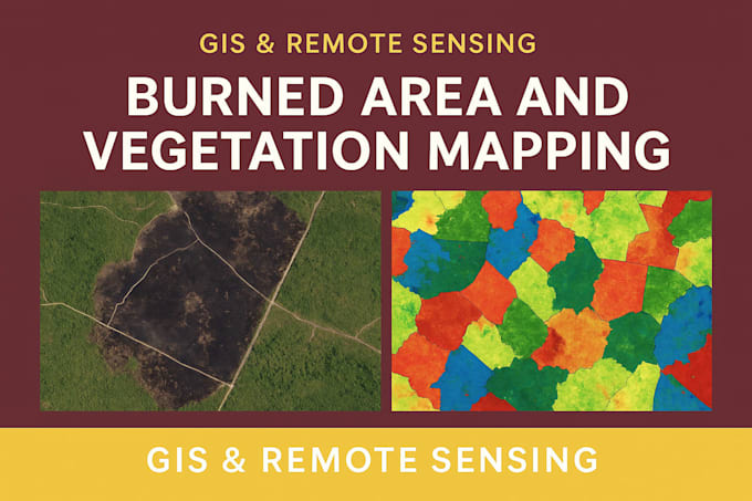
I am currently a PhD researcher at Arkansas State University, where I work as a Geospatial Analyst focusing on advanced spatial data analysis and environmental applications. My research integrates Geographic Information Systems (GIS), remote sensing, and spatial modeling to address real-world environmental and land management challenges. I have extensive experience in processing, cleaning, and analyzing large-scale geospatial datasets from sources such as satellite imagery, public geodatabases, and field surveys. I regularly use industry-standard tools including ArcGIS, QGIS, and programming languages like Python to automate workflows, perform spatial analysis, and generate high-quality visualizations. My work involves land use and land cover analysis, crop and environmental monitoring, and evaluating spatial patterns to support sustainable resource management. I also focus on optimizing geospatial data for performance, particularly for mobile and web-based mapping applications, ensuring efficient rendering and usability without compromising spatial accuracy. In addition to technical analysis, I contribute to research design, data interpretation, and scientific communication, presenting findings through maps, reports, and academic publications. My interdisciplinary background allows me to bridge the gap between data science and environmental research, delivering insights that support informed decision-making. Overall, I am passionate about leveraging geospatial technologies to solve complex problems and create scalable, data-driven solutions in environmental science and beyond.
| (1) | ||
| (0) | ||
| (0) | ||
| (0) | ||
| (0) |
brysen_jacobsen

Estados Unidos
He was amazing to work with, asked good detailed questions to make sure he got exactly what I wanted the first time and delivered faster than expected. I would definitely work with him again in the future for any arcgis related work.