Ver categorias
Explorar
Fiverr Pro
Português
$
USD


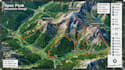
I specialize in creating custom, visually engaging maps for parks, trails, hiking routes, and outdoor adventure locations. Whether you need a detailed trail map for hikers, a travel map for tourists, or an illustrated map for your park or adventure business, I can deliver clear, professional, and accurate designs.
My services include:
Why Choose Me
I work with both simple and complex projects, adapting the map style and level of detail to match your needs.
Before Ordering:
Please provide any available reference materials such as GPS data, sketches, Google Maps screenshots, trail information, logos, branding guidelines, or points of interest you would like included.
Informe o freelancer sobre suas preferências ou preocupações em relação ao uso de ferramentas de IA na conclusão e/ou entrega de seu pedido.
map designer
Idiomas
Can you create an illustrated map from my reference materials?
Yes. I can work from Google Maps, GPS data, sketches, satellite images, photos, or other references to create a custom illustrated map.
Can you customize the map to match my preferred style?
Absolutely. I can create a clean, detailed, illustrated, or adventure-style map based on your requirements and reference examples.
Can you include trails, landmarks, routes, and points of interest?
Yes. I can include trails, roads, landmarks, viewpoints, facilities, routes, labels, and other important locations you need on the map.


