Ver categorias
Explorar
Fiverr Pro
Português
$
USD

Geo Mapping Solutions from GIS and REMOTE SENSING EXPERT
Habilidades
Conheça meus serviços
Remote Sensing Consultant
Geo Set • Período integral
Dec 2021 - Present • 4 yrs 7 mos
Alhamdulillah! I am thrilled to share that I have joined Geo Set Zambia Limited as a Remote Sensing Consultant! 🚀 In this role, I will be leveraging advanced remote sensing and geospatial analysis to support geological and mining consultancy operations. From satellite image processing to data-driven insights, I look forward to contributing my expertise to drive innovative solutions in the field.
Founder and CEO
StudyHacks(Institute of GIS, AI and Remote Sensing ) • Autônomo
Jul 2020 - Present • 6 yrs
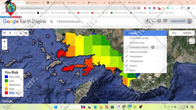
I am Md. Mijanur Rahman, a passionate geospatial professional and lifelong learner driven by the vision of making GIS, Remote Sensing, and AI accessible to all. As the Founder & CEO of Study Hacks – Institute of GIS, Remote Sensing & AI, I have built a platform dedicated to empowering students, researchers, and professionals with hands-on skills to solve real-world problems using cutting-edge geospatial technologies. My journey began with a fascination for how satellite data and AI can transform our understanding of the Earth. Over the years, I have honed my expertise as a Computer Vision & Deep Learning Consultant for Geospatial Data, applying advanced algorithms for tasks like land cover mapping, environmental monitoring, object detection, and change analysis. As an Environmental Researcher, I have contributed to projects in climate risk assessment, agricultural productivity monitoring, water resource management, and sustainable urban planning. I firmly believe that geospatial intelligence can drive informed decision-making and bring tangible solutions to pressing environmental challenges. In addition to research and consultancy, I am deeply passionate about teaching and mentoring. Through live training programs, workshops, and personalized mentorship, I have helped hundreds of learners worldwide develop strong foundations in GIS, Remote Sensing, and AI. My mission is simple yet impactful: to bridge the gap between geospatial technology and practical solutions for a sustainable future. #googleearthengine #remotesensing #GIS #GEE #EarthEngine
Lead Consultant for Satellite Remote Sensing on Mining Surveying and Operations Lead Consultant for Satellite Remote Sensing on Mining Surveying and Operations
WAMSO • Meio período
Mar 2020 - Present • 6 yrs 4 mos
Alhamdulillah! Thrilled to share that I've been appointed as the Lead Consultant for Satellite Remote Sensing for the Geospatial International Standard Mining Resources Survey (GISMRS) project in Nigeria It's an honor to contribute to such a vital initiative, harnessing satellite technology to drive sustainable resource management and economic development. Pray for me to keep up my best work in the future to achieve bigger success in this field to grow my career!
| (35) | ||
| (2) | ||
| (1) | ||
| (0) | ||
| (1) |
jumaniyozboy

Uzbequistão
Professional approach to his work. Fully detailed and in-depth knowledge
Resposta do freelancer

kgteh2

Malásia
Resposta do freelancer
kien_vietnam

Vietnã
Thanks Mijanur Rahman very much for your kind help.

Resposta do freelancer
huongdo_husc
Vietnã
Thank you for your kind and patient support for the pre-course. Your response and guidance are very fast and emerge for the best solution.

Resposta do freelancer
arsangungor

Turquia
He was really fast and helpful with everything, I was very pleased to work with him. I recommend others to work with him.

Resposta do freelancer