Ver categorias
Explorar
Fiverr Pro
Português
$
USD

Tradução automática
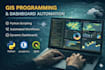
Eu ofereço soluções profissionais de GIS e geoespacial, incluindo mapeamento, análise espacial, sensoriamento remoto, processamento de geodados e automação de GIS. Trabalho com ArcGIS, ArcGIS Pro, QGIS, Python e Model Builder para entregar resultados precisos e de alta qualidade, adaptados às necessidades do projeto.
Meus serviços incluem mapeamento temático, gerenciamento de geobases de dados, análise de dados espaciais, roteirização de redes, análise de terreno, processamento de dados de drones, geo-visualização e fluxos de trabalho personalizados de GIS. Meu foco é criar conjuntos de dados e mapas limpos e organizados que apoiem um planejamento e tomada de decisão melhores.
Por que escolher meus serviços?
Resultados de GIS precisos e confiáveis
Entrega rápida e comunicação clara
Fluxos de trabalho personalizados para cada projeto
Apoio profissional durante todo o projeto
Experiência em projetos:
Roteirização de redes ferroviárias e fluxos de trabalho de GIS empresarial
Imagens de drones de alta resolução e geração de contornos
Automação de GIS para melhorar a eficiência do processamento
Feedback dos clientes:
Trabalho profissional com alta precisão e entrega pontual.
Altamente qualificado em mapeamento e análise espacial.
GIS Expert
Idiomas
Tradução automática
Tradução automática
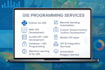
Com quais softwares/bibliotecas de GIS você trabalha?
ArcGIS Pro, QGIS, GDAL, Rasterio, Geopandas, PostGIS, Leaflet, Mapbox, ArcGIS API/SDK, Python, Javascript e outros.
Você desenvolve sistemas completos de Web GIS?
Sim, eu desenvolvo dashboards completos de Web GIS, mapas interativos e fluxos de trabalho de GIS baseados em servidor.
Você consegue automatizar fluxos de trabalho de sensoriamento remoto?
Com certeza — incluindo classificação, recorte, mosaico, índices e detecção de mudanças.
Você oferece caixas de ferramentas personalizadas para ArcGIS/QGIS?
Sim, posso criar ferramentas de geoprocessamento e plugins personalizados.
Como você garante a privacidade dos meus dados de GIS ou do projeto?
Todos os dados do cliente são tratados com confidencialidade rigorosa. Arquivos do projeto, mapas, coordenadas, imagens, bancos de dados e documentos são usados apenas para o escopo acordado do projeto e nunca são compartilhados com terceiros.


