Parece que este serviço está em espera

I will convert your kml google earth data into professional autocad dwg files

J
joh_wealth
J
joh_wealth
John
Algumas informações são exibidas no idioma inglês.

Sobre este Serviço

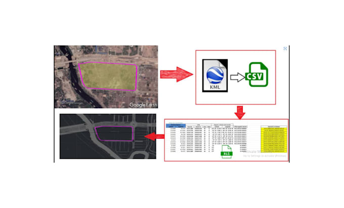
Stuck with a KML file that your architect or engineer cant use?


Google Earth is great for visualization, but its a nightmare for construction and design. If you try to build or plan using raw KML data, you'll quickly find that the scales are off, the coordinates don't align, and the file lacks the professional layers required for AutoCAD.

I provide a seamless, high-precision conversion service to turn your Google Earth KML/KMZ data into professional, layered, and georeferenced AutoCAD DWG/DXF files.


WHAT I OFFER

  • Coordinate Correction: I ensure your data is projected into the correct UTM or State Plane coordinate system.
  • Layer Management: I dont just dump lines. I organize your data into clean, logical layers (Boundaries, Paths, Markers).
  • Elevation Data: If your KML has 3D data, I can extract and convert it into usable 3D polylines or contours.
  • Scaling: I ensure 1:1 scaling so your measurements are accurate for real-world application.

Stop fighting with incompatible files. Let me handle the technical conversion so you can get back to designing.

Please message me and attach your KML/KMZ file before ordering.


Let Get Started

Click the Contact Me button now


Preferência de verificação de serviço e estilo de entrega

A Fiverr não seleciona freelancers nesta categoria. Favor verificar os requisitos de qualificação com o freelancer antes de realizar o pedido, incluindo as preferências em relação ao uso de ferramentas de IA.

Conheça mais sobre John

John

Land surveying and geospatial

  • A partir deEstados Unidos
  • Membro desdeabr. de 2026
  • Idiomas

    Inglês, Francês, Espanhol, Alemão, Italiano
With over 8 years of experience in land surveying and geospatial analysis, I help developers, architects, and homeowners turn complex land data into actionable, high-precision blueprints. My expertise lies in bridging the gap between raw field data (KML, GPS, Total Station points) and professional AutoCAD Civil 3D environments. Whether you need an accurate topographical map, a complex plot subdivision, or a critical boundary line analysis, I deliver files that are 100% construction-ready and georeferenced.

Tags relacionadas