Ver categorias
Explorar
Fiverr Pro
Português
$
USD

Level 1

Tradução automática
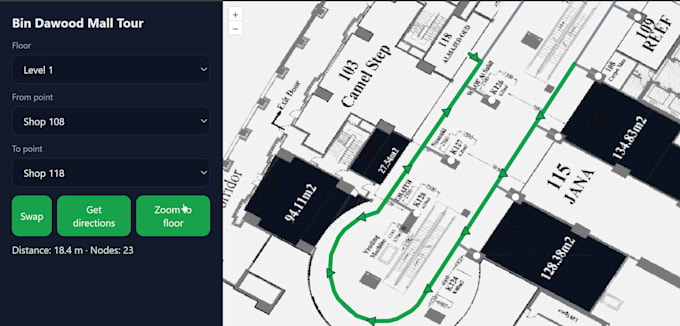
Vou transformar seus planos de construção, desenhos CAD ou plantas em um mapa interno totalmente interativo e um sistema de navegação indoor baseado na web. Seja para um overlay básico de piso, mapeamento de múltiplos andares, integração com sistema de posicionamento indoor (IPS) ou uma orientação indoor avançada, entrego soluções modernas, responsivas e fáceis de usar.
Meus serviços incluem Pontos de Interesse (POIs) pesquisáveis, roteamento de múltiplos andares, controle de acesso, atualizações de mapas em tempo real, rastreamento de ativos internos e legendas e simbologia personalizadas. Posso integrar IndoorGML, modelos BIM, conversão de CAD para GIS e tiles vetoriais para alto desempenho.
A aplicação web de mapeamento interno é desenvolvida usando tecnologias de GIS de ponta, como OpenLayers, Mapbox GL JS, Leaflet, PostGIS, GeoServer e implantações prontas para nuvem (AWS, Azure, GCP). Seu mapa funcionará perfeitamente em todos os dispositivos, com design responsivo e opções para quiosques touchscreen, mapas internos compatíveis com mobile e painéis interativos de orientação.
Perfeito para <strong shopping malls, aeroportos, hospitais, universidades, escritórios corporativos, fábricas, depósitos, prédios governamentais, museus e locais de eventos onde você precisa de uma visualização precisa de dados espaciais internos.
GIS Tech
Level 1
Idiomas
Tradução automática
