Ver categorias
Explorar
Fiverr Pro
Português
$
USD

Level 1
GIS Professional and Researcher
Habilidades
Conheça meus serviços

Quer trabalhar com remuneração por hora?
Diga a M. Irfan o que você precisa.
US$ 15
/
horaSenior GIS Executive
Sui Southern Gas Company Limited. • Período integral
Feb 2009 - Jan 2021 • 11 yrs 11 mos
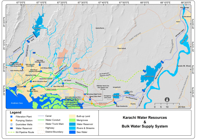
▪ Effectively coordinate with the Team Lead in Planning and organizing the project related activities. ▪ Provide GIS representation and technical assistance by attending meetings, providing employees with instruction, and coordinating work with other P&D and Engineering departments. ▪ Produce maps in as required for Operational and Maintenance activities, system analysis, growth projects, etc. ▪ Design and update Standard Operating Procedures (SOPs) with the coordination of technical support team for CAD & GIS data (base-map & gas network assets) development. ▪ High resolution satellite image processing, geo-referencing/rectification of satellite images and scanned hardcopy maps. ▪ Land use mapping using high spatial resolution satellite images, and surveyed data. ▪ Gas pipeline networks/assets management using ArcGIS and ArcFM. ▪ ArcGIS and ArcFM based gas distribution pipeline network mapping up to the level of gas consumer meter-settings. ▪ Geometric network-based geodatabase designing, development and modelling of gas distribution pipelines. ▪ Geodatabase development, designing and modelling including geometric networking for Gas pipeline network. ▪ QA/QC of GIS data as per defined Standard Operating Procedures (SOPs). ▪ Large scale map layout designing and printing. ▪ GPS survey for transmission and distribution pipeline networks including gas installations like gas valves, TBS (Town Border Station), and PRS (Pressure Reducer Station) etc. ▪ GPS survey for getting geo-tagged snapshots of all Gas network installations. ▪ Incorporation of GPS survey data in GIS system.
Data Processor/Photogrammetrist
FUGRO Geodetic • Período integral
May 2007 - Aug 2007 • 3 mos
▪ 3D Mapping of different Australian & Middle Eastern Projects by ArcGIS, AutoCAD, SOCET SET & MicroStation Software. ▪ DEM (Digital Elevation Model) creation, editing, and QA. ▪ TIN (Triangulated Irregular Network) creation. ▪ Interactive Terrain Extraction ▪ Finalizing Contour Data and conversion into CAD Form ▪ Data capturing for surface modelling ▪ Break lines for feature extraction ▪ Base mapping for plotting the area ▪ Surface generation with the help of contours
| (18) | ||
| (0) | ||
| (0) | ||
| (0) | ||
| (0) |
katebennett836
Cliente recorrente

Reino Unido
Literally the best individual I have worked with on Fiverr. So incredibly patient, professional, competent and helpful! Absolutely brilliant - would give more than 5 stars if I could!
Resposta do freelancer
bdaphd

Dinamarca
M. Irfan delivered exceptionally professional work and demonstrated an impressive level of cooperation and politeness throughout the project. He truly went above and beyond to meet my needs. Highly recommended! 👌
deekhalid

Bahrein
Well done! Exactly what I wanted in a short amount of time.
Resposta do freelancer
nagendrakuma459
Cliente recorrente

Índia
That was a quick and accuracy delivery, Thanks for your efforts.
Resposta do freelancer
in8inteligence
Cliente recorrente

Holanda