Ver categorias
Português
$
USD
Conecte-se à sua IA

PUT MY EFFORTS INTO YOUR BUSINESS
Habilidades
Conheça meus serviços

Senior Python AI Lead
ACME One • Freelance
Aug 2025 - Present • 1 yr 3 mos
I have contributed to multiple SaaS products as AI and Full-Stack, reduced AI bill by 40%, optimized backends to reduce latency by 80%, and AI Agents orchestration to automate the manual stuff that takes weeks.

Senior DevOps Engineer
Pvragon • Período integral
Feb 2026 - Aug 2026 • 6 mos
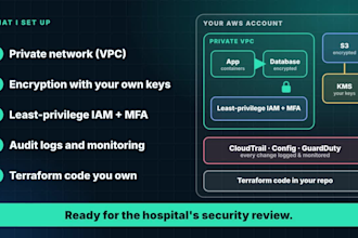
Designed, built, and owned the complete AWS infrastructure for Echo1 V2, a multi-tenant Non-Emergency Medical Transportation (NEMT) SaaS platform handling PHI under HIPAA, from initial architecture through production launch.

Senior Backend Engineer
ENPLAN Environmental and Geospatial Technologies • Período integral
Feb 2021 - Jul 2023 • 2 yrs 5 mos
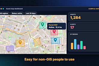
At ENPLAN, I contributed to the backend architecture of MapPort, a cloud-based geospatial intelligence platform used for environmental analysis, land planning, and risk assessment. I engineered and optimized APIs that powered interactive mapping layers, parcel-level insights, and advanced spatial queries. I improved data pipelines for large geospatial datasets related to zoning, wildfire risk, flood zones, soil classification, and government environmental records. My focus included performance optimization, data model refinement, indexing strategies, caching, and CI CD improvements to ensure the platform remained fast, stable, and scalable as datasets grew. I collaborated with product and GIS teams to translate complex environmental use cases into reliable backend features and well-structured endpoints.
| (1) | ||
| (0) | ||
| (0) | ||
| (0) | ||
| (0) |

dozy11

Nigéria
He was very supportive and good with pyhton QGIS plugin development. I would always recommend him.
US$ 100-US$ 200
Preço
