Ver categorias
Explorar
Fiverr Pro
Português
$
USD
Geographic Information System and CAD Expert
Habilidades
Conheça meus serviços
GIS & CAD Expert
AGES Consultant • Período integral
Apr 2008 - Present • 18 yrs 3 mos
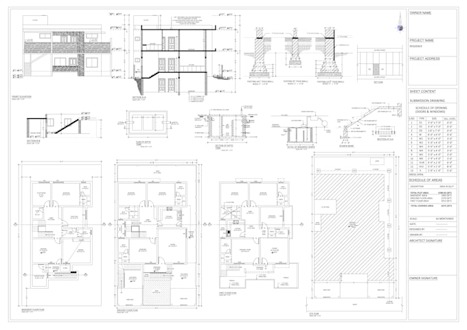
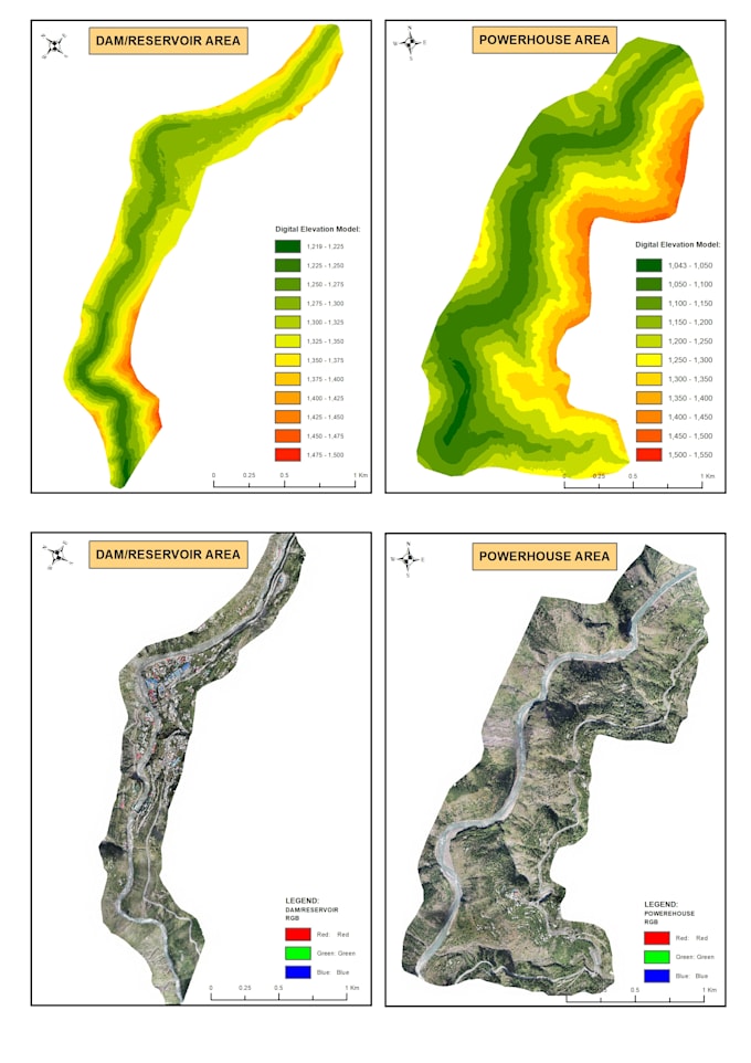
Highly experienced Senior CAD Designer with 16+ years delivering engineering drawings for hydropower, irrigation, drainage, roads, and infrastructure projects. Proven ability to produce accurate, construction ready drawings integrated with GIS and survey data. Strong background in AutoCAD 2D/3D, revision control, and compliance with international engineering standards and EPC projects. 6. Key Achievements Produced complete design and construction drawings for hydropower, irrigation, drainage, roads and infrastructure projects. Delivered as-built drawings, and detailed drawings reducing construction clarifications and rework. Integrated survey, GIS, and photogrammetry data into CAD drawings for improved site accuracy. Supported multidisciplinary teams (civil, electrical, and mechanical) across energy and water projects. Maintained drawing databases and revision systems for long-term, multi-phase projects. GIS Expert with 16+ years of experience delivering geospatial solutions for hydropower, irrigation, watershed management, flood analysis, and infrastructure projects. Proven record of supporting large scale energy and water projects through DEM modeling, UAV photogrammetry, spatial analysis, and GIS based land acquisition systems. Strong ability to translate complex spatial data into decision ready maps, dashboards, and planning tools. 6. Key Achievements Delivered GIS and photogrammetric solutions for 300MW Balakot Hydropower Project, Gabral Kalam HPP , Kari Mashkur HPP, Barum Gol HPP, supporting land acquisition, design, and environmental planning across 1,000+ km². Developed GIS based Land Information & Adjudication Systems, improving land record accuracy and reducing acquisition disputes. Produced high resolution orthomosaics, DTM, contours, and slope models using UAV & LiDAR data for complex mountainous terrain. Supported EIA/EMP studies through ecological, hydrological, and land-use mapping, improving environmental compliance. Enabled flood
| (2) | ||
| (0) | ||
| (0) | ||
| (0) | ||
| (0) |

ryan2020

Estados Unidos
Had a great experience.
celleran

Austrália
excellent work

Resposta do freelancer
