Ver categorias
Explorar
Fiverr Pro
Português
$
USD


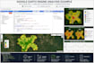
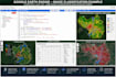
Google Earth Engine (GEE), NDVI & Remote Sensing Services
I provide professional Google Earth Engine (GEE) and remote sensing solutions for research, agriculture, environmental monitoring, urban planning, and business projects. Deliverables include satellite imagery processing, geospatial analysis, maps, reports, visualizations, and reusable code.
Services:
NDVI, NDWI, NDBI analysis
Time-series analysis
Change detection
Land Use/Land Cover classification
Vegetation, water, and urban monitoring
Landsat, Sentinel, and MODIS processing
Custom maps, charts, and reports
GEE JavaScript/Python scripting
Basic ($10):
NDVI, NDWI, NDBI or imagery download
Up to 5 years of data
GeoTIFF/CSV outputs
Delivery: 2 days | 2 revision
Standard ($20):
Everything in Basic
Trend analysis and time-series charts
Statistical summaries
Custom visualizations
Delivery: 3 days | 4 revisions
Premium ($30):
Everything in Standard
Supervised classification
Change detection
Complete GEE code
Methodology documentation
Delivery: 6 days | 6 revisions
To get started, provide your area of interest, time period, required analysis, and selected package.
GIS Expert, Remote Sensing Specialist, Data Analyst, AI ML Specialist, Drone Pil
Idiomas


