Ver categorias
Explorar
Fiverr Pro
Português
$
USD

Level 1

Tradução automática
Se você procura serviços de GIS usando ArcMap, ofereço várias opções:
1. Análise Geoespacial:
- Criação de buffers
- Análise de recorte
- Extração por máscara
- Remoção de erros topológicos
- Operações espaciais como Join, Union e Intersection
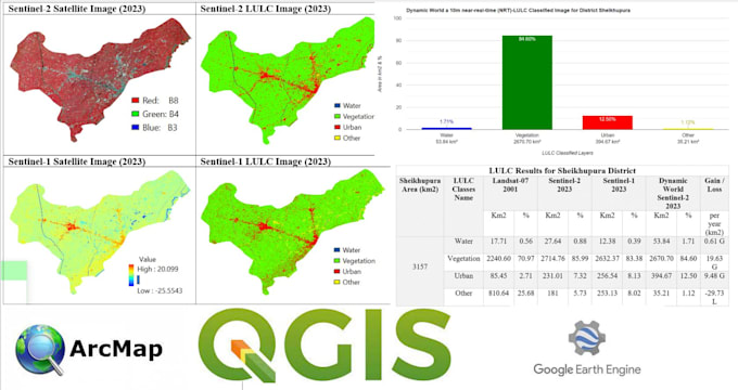
2. Mapeamento de uso da terra e cobertura vegetal
3. Entrada de atributos e ordenação de dados:
- Com base em atributos
4. Vetorização e rasterização
5. Análise de imagens:
- Classificação
- Índices espectrais (por exemplo, NDVI, NDWI)
- Composição de imagens
6. Tarefa do Model Builder
7. Criação de mapas temáticos
8. Ferramentas de conversão de dados:
- Shapefile, Feature Class, Geodatabase, KML
- Ajustes de sistema de coordenadas e projeções
9. Digitalização + Georreferenciamento
10. Análise de bacias hidrográficas
Sinta-se à vontade para entrar em contato antes de fazer seu pedido para discutir suas necessidades específicas. Estou aqui para ajudar com qualquer dúvida ou solicitação relacionada a GIS.
GIS and RS Analyst Python Google Earth Engine Arcpro Qgis
Level 1
Idiomas
Tradução automática
Tradução automática
Você pode explicar brevemente a análise geoespacial?
Análise geoespacial envolve examinar relações espaciais dentro de dados geográficos. Isso inclui operações como buffers, recortes e junções espaciais para análises aprofundadas.
O que é GIS?
GIS significa Sistema de Informação Geográfica. É uma tecnologia que captura, analisa e apresenta dados espaciais ou geográficos.
Como funciona a classificação de imagens no GIS?
Classificação de imagens envolve categorizar pixels em uma imagem de satélite ou aérea em diferentes classes, ajudando a identificar recursos como vegetação, água ou áreas urbanas.
O que é análise de bacias hidrográficas?
A análise de bacias hidrográficas avalia o fluxo de água sobre uma área específica, identificando fatores contribuintes e ajudando na gestão de recursos hídricos.
Que tipo de dados podem ser convertidos usando as ferramentas de conversão de dados?
Ferramentas de conversão de dados são usadas para converter entre diferentes formatos de dados GIS, como Shapefiles, Feature Classes, Geodatabases, KML, e para gerenciar sistemas de coordenadas e projeções.